Deo Tibba Peak Expedition
Explore this trek
Swipe →Overview
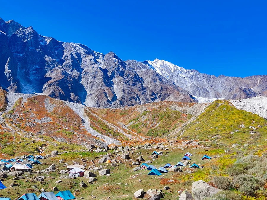
Deo Tibba Peak Expedition is a difficult high altitude mountaineering expedition that can be undertaken in the Pir Panjal Range of Kullu district in Himachal Pradesh, India. Deo Tibba Peak reaches an elevation of about 6,001 meters (19,688 feet) and is one of the highest peaks in the Manali region, known for its unique dome shaped peak, glaciers and Himalayan landscape. In accordance with Hindu mythology, Deo Tibba is regarded as the meeting point of the gods.
The trail of the expedition starts near Jagatsukh village, located very close to Manali. The route winds through the scenic valley of Duhangan in thick forests, crossings of rivers, high mountain pastures, and other natural features. The path goes through Chikka and the stunning meadows of Seri towards the Tainta Base Camp that is located below the majestic peak of Deo Tibba. Above the base camp the land is covered with glaciers and moraine formations.
The route up in the mountains is rather tough as it involves glaciers, steep slopes with snow and ice, ridges, and other difficult high-mountain conditions.
The Deo Tibba expedition provides one with such an exciting opportunity due to its spectacular landscape and culture-rich environment coupled with the challenging alpine nature of the region.
Photos and videos
2 photos · tap to viewHighlights
6 points- Deo Tibba Base Camp Trek
- Deo Tibba Peak Expedition
- Duhangan Valley
- Seri Meadow
- Chota Chandratal
- Mount Indrasan
Trek Details
- Total Distance
- 60 km
- Best Time
- May–June and September–October
- Base Camp
- Manali
- Route Type
- Out And Back
- Accommodation
- Tents
- Fitness Level
- Expert
- Family Friendly
- Check with operator
- Season
- Summer, Autumn, Monsoon
- Terrain
- Snow, High altitude, Ridge walk, Rocky Trail, Summit View, Valley, Meadow, Lake
- Departure Cities
- Manali, Kullu
- Region
- Kullu Valley, Himachal Pradesh, India
Itinerary
13 days · tap a dayDay 1
Arrive in Manali
Altitude: 2,050 m (6,750 ft) Reach Manali by about 10 am and check in to the hotel.
Day 2
Manali to Chhikka
Altitude: 3,100 m (10,200 ft) Distance: 15 km drive (about 1 hr), then a 5 km trek (2–3 hrs) You drive towards Jagatsukh and walk to Chhikka, gaining about 1,000 m. It is a short first day, but the gain is large, so go slowly.
Day 3
Chhikka to Seri
Altitude: 3,850 m (12,600 ft) Distance: 8 km (5–6 hrs) You follow the right bank of the Jagatsukh Nallah through forest and birch. Seri is a large green grassland and was once a glaciated lake. You get views of Deo Tibba and the neighbouring peaks.
Day 4
Seri to Deo Tibba Base Camp
Altitude: 4,500 m (14,800 ft) Distance: 8 km (5–7 hrs) The altitude gain is about 650 m over rougher, rockier ground. You arrive at Base Camp, a campsite surrounded by peaks.
Day 5
Rest and acclimatisation
Altitude: 4,500 m Rest, hydrate and explore around camp.
Day 6
Load ferry to Camp 1 (Duhangan Col)
Altitude: 5,100 m (16,800 ft) Duration: 4–5 hrs You carry gear up to Camp 1 and come back down to Base Camp to sleep. This helps your body adapt: climb high, sleep low.
Day 7
Base Camp to Camp 1
Altitude: 5,100 m (16,800 ft) Duration: 5–6 hrs You move up with your personal kit and sleep at Camp 1 on Duhangan Col.
Day 8
Load ferry to Summit Camp
Altitude: 5,600 m (18,400 ft) Distance: 4 km (4–5 hrs) Another carry, this time to Summit Camp, followed by a return to Camp 1 to sleep.
Day 9
Camp 1 to Summit Camp
Altitude: 5,600 m (18,400 ft), a gain of 500 m You move up to Summit Camp, your highest sleeping point. Eat, rest and prepare for the summit.
Day 10
Summit attempt and back to Camp 1
Altitude: Summit 6,000 m (19,700 ft), then down to Camp 1 at 5,100 m Distance: 6 km (4–6 hrs) Deo Tibba demands mountaineering-style climbing with fixed ropes, crampons and ice axes. The summit is a snow dome that looks like an ice cap. You make the attempt from Summit Camp, then descend to Camp 1 for the night.
Day 11
Camp 1 to Base Camp
Altitude: 5,100 m → 4,500 m Distance: 3 km (3–4 hrs) A short descent. You get back to Base Camp for a hot meal and rest.
Day 12
Base Camp to Chhikka
Altitude: 4,500 m → 3,100 m Distance: 16 km (6–8 hrs) This is the longest day, a descent of about 1,400 m. It is tough on the knees, so trekking poles help.
Day 13
Chhikka to Manali
Altitude: 3,100 m → 2,050 m Distance: 5 km trek (2–3 hrs), then the drive back
Things to Carry
- 40–50L backpack
- daypack
- trekking shoes
- trekking poles
- gaiters
- backpack rain cover
- headlamp with spare batteries
- Thermal base layers
See all 45 items
- quick-dry T-shirts
- trekking pants
- fleece jacket
- down jacket
- waterproof jacket
- waterproof pants
- warm socks
- woollen cap
- sun hat
- insulated gloves
- spare undergarments
- Water bottles or hydration bladder
- water purification tablets/filter
- energy bars
- dry fruits
- electrolyte sachets
- First-aid kit
- personal medicines
- blister patches
- sunscreen (SPF 50)
- lip balm
- UV-protection sunglasses
- power bank
- charging cable
- camera (optional)
- spare batteries
- Toothbrush
- toothpaste
- biodegradable soap
- hand sanitiser
- wet wipes
- toilet paper
- tissues
- quick-dry towel
- waste bags
- Government-issued photo ID
- Power bank
Compare Operators
Find the best deal
Share your dates and group size, and verified trek companies will send you their prices. Free, no obligation.
Trek Profile
Overall: Extreme
Best Suited For
- Veteran Trekkers
- High Altitude Experience
- Endurance Athletes
Not Ideal For
- Beginners
- Casual Hikers
- People with Health Concerns
Trek reviews
Reviews are opening soon for Deo Tibba Peak Expedition. Share the route, season, difficulty, and trail experience.
Trail Tales For This Trek
Explore More In Kullu Valley
Free quotes from operators
Interested In This Trek?