
Overview
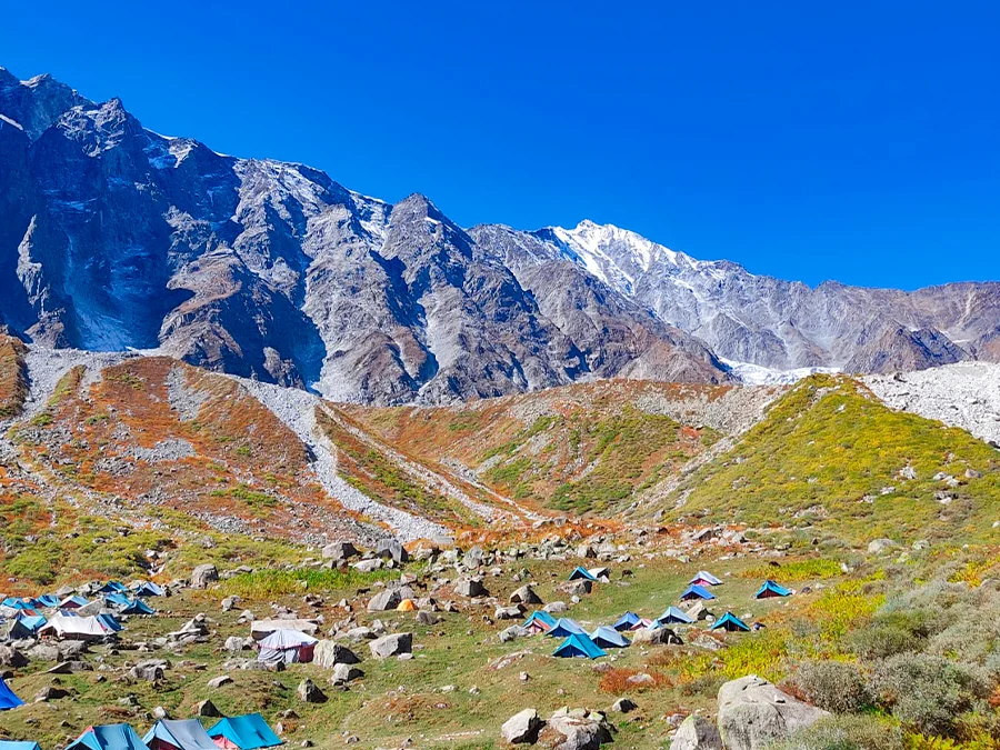
Chandrakhani Pass Trek starts from the Kullu district of Himachal Pradesh and is a traditional path connecting the valley of Kullu with Malana area of Parvati. The Chandrakhani pass Trek is renowned for its scenic beauty, which begins with terraced farming areas and forests before gradually opening up to high altitude pastures.
Most routes will start from either Naggar or Rumsu, and campsites are usually set up around areas like Naya Tapru and Chaklani. The route takes you up to the Chandrakhani Pass, which is about 3,660 meters high. On clear days, there could be great views of the Pir Panjal and Dhauladhar ranges along with some of the notable mountains including the Deo Tibba range.
The hike is usually classified as easy to moderate or moderate but this may depend upon the time of year, snow levels, the route taken and the fitness of the hiker. There will be snow at higher altitudes during late spring and rain during monsoon can create slippery routes and poor visibility. The months of September and October have clear post monsoon weather but this may vary from year to year.
Photos And Videos
Highlights
- Panoramic mountain views
- Open alpine meadows
- Rumsu village heritage
- Malana Valley connection
Trek Details
Seasons
Departure Cities
Terrain
Itinerary
- 1
Manali to Rumsu Village
Route: Manali → Rumsu Distance travelled: Approximately 18–30 km by road, depending on the starting point Trekking distance: No major trekking; optional short walk Altitude: Manali — approximately 6,400 ft; Rumsu — approximately 6,800 ft Activities: Travel to Rumsu, settle into the campsite or accommodation, attend the route briefing and prepare for the trek.
- 2
Rumsu to Naya Tapru
Route: Rumsu → Ghan Kuradi → Naya Tapru Trekking distance: Approximately 4–6 km Walking time: Around 4–6 hours Altitude: Rumsu — approximately 6,800 ft; Naya Tapru — approximately 10,400–10,600 ft Activities: Climb through forest trails and gradually reach the open meadows. Enjoy views of the surrounding Kullu mountains.
- 3
Naya Tapru to Chaklani Camp
Route: Naya Tapru → Chaklani Trekking distance: Approximately 2–3 km Walking time: Around 2–3 hours Altitude: Naya Tapru — approximately 10,400–10,600 ft; Chaklani — approximately 11,300–11,400 ft Activities: Continue into the alpine meadows and rocky terrain below the pass. Rest at camp and follow your guide's advice about the following day's route.
- 4
Chaklani to Chandrakhani Pass and Return to Naya Tapru
Route: Chaklani → Chandrakhani Pass → Naya Tapru Trekking distance: Approximately 8–10 km Walking time: Around 6–9 hours Altitude: Chaklani — approximately 11,400 ft; Chandrakhani Pass — approximately 12,000–12,185 ft; Naya Tapru approximately 10,400–10,600 ft Activities: Reach the pass for views across the surrounding Himalayan ranges, then descend toward Naya Tapru. Snow and weather can change the difficulty, so follow your qualified guide's assessment.
- 5
Naya Tapru to Rumsu and Return to Manali
Route: Naya Tapru → Rumsu → Manali Trekking distance: Approximately 4–6 km Walking time: Around 3–5 hours Driving distance: Approximately 18–30 km to Manali, depending on the transport arrangements Altitude: Naya Tapru — approximately 10,400–10,600 ft; Rumsu — approximately 6,800 ft; Manali — approximately 6,400 ft Activities: Descend through the forest to Rumsu and take the arranged vehicle back to Manali.
Things to Carry
Trek reviews
Reviews are opening soon for Chandrakhani Pass Trek. Share the route, season, difficulty, and trail experience.