Satopanth Peak Expedition
Explore this trek
Swipe →Overview
The Satopanth Peak Expedition is a tough expedition that involves climbing a high peak situated in the Gangotri Range in the Garhwal region of Uttarakhand, India. The height of Mount Satopanth is roughly 7,075 meters (23,212 feet), making it one of the highest peaks in the Gangotri mountain range in India. Mount Satopanth is surrounded by some magnificent Himalayan peaks such as Chaukhamba, Shivling, and Bhagirathi.
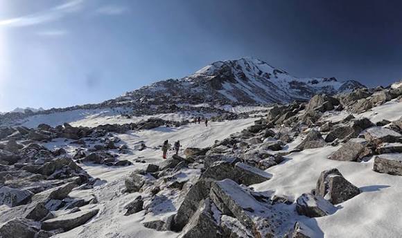
The climb starts out on the mountain via Gangotri, traversing one of the most striking terrains of the higher Gangotri zone. The normal route leads via Bhojbasa, Gaumukh, Tapovan, Nandanvan and finally to Vasuki Tal, where the base camp is set up. Some of the highlights of this climb include the glaciated valley, rock moraines, spectacular ice faces and rugged terrain.
Some of the features of the climbing route involve glacier crossings, technical climbs through steep snow/ice, rock passages, steep ridge and summit of the mountain.
This is because the Satopanth Peak Expedition features an exciting blend of technical climbing, breathtaking Himalayan landscapes, and mountaineering history, which makes the expedition a great success for mountaineering at high altitudes.
Photos and videos
2 photos · tap to viewHighlights
7 points- Satopanth Tal
- Satopanth Peak
- Gangotri
- Bhojbasa
- Tapovan and Nandanvan
- Vasuki Tal
+1 more highlights
- Satopanth massif
Trek Details
- Total Distance
- 79 km
- Best Time
- June–September
- Base Camp
- Gangotri
- Route Type
- Out And Back
- Accommodation
- Tents
- Fitness Level
- Expert
- Family Friendly
- Check with operator
- Season
- Summer, Autumn, Monsoon
- Terrain
- Snow, High altitude, Lake, Ridge walk, Rocky Trail, Summit View, Valley
- Departure Cities
- Dehradun, Rishikesh, Haridwar, Uttarkashi, Gangotri
- Region
- Garhwal, Uttarakhand, India
Itinerary
10 days · tap a dayDay 1
Arrive in Gangotri
Altitude: 3,100 m (10,200 ft) Distance: 250 km drive (8–9 hrs) from Dehradun
Day 2
Rest and acclimatisation in Gangotri
Altitude: 3,100 m A rest day. After lunch you can visit the Gangotri Temple or shop for last-minute items. Keep it easy and drink plenty of water.
Day 3
Gangotri to Bhojwasa
Altitude: 3,100 m → 3,800 m (12,500 ft) Distance: 14 km (about 7 hrs) The trek starts on the Gaumukh trail inside Gangotri National Park, gaining about 700 m. Bhojwasa is the last major camping stop before the glacier.
Day 4
Bhojwasa to Nandanvan
Altitude: 3,800 m → 4,500 m (15,000 ft) Distance: 8–9 km (5–6 hrs) You pass Gaumukh, the glacier that feeds the Ganga, and reach Nandanvan, a campsite with views of Shivling. Expect rough glacial moraine and another 700 m of altitude gain.
Day 5
Nandanvan to Vasuki Tal (Base Camp)
Altitude: 4,500 m → 5,000 m (16,400 ft) Distance: 7 km (4–5 hrs) You cross the Chaturangi Glacier area and arrive at Vasuki Tal, beside the lake, which is your Base Camp for the climb.
Day 6
Rest, acclimatisation and training at Base Camp(Day 6-7)
Altitude: 5,000 m Two days at Base Camp. You check equipment and practise basic snow and ice craft. The rest days are highly advisable for acclimatisation, and you should treat them as essential.
Day 7
The climb (Base Camp to the summit and back)(Day 8-19)
Altitudes: Advance Base Camp: 5,140 m (16,900 ft) Camp 1: 5,750 m (18,900 ft) Camp 2: 6,200 m (20,300 ft) Summit: 7,075 m (23,210 ft) Distance: about 17 km of the 79 km total falls in this phase, with no per-day breakdown. The schedule depends on the weather. These days cover load ferries between camps, acclimatisation and buffer time for bad weather. You work up through the camps using crampons, fixed ropes and jumars. Below the summit is the Knife Ridge, a narrow, technical section with near-vertical drops on both sides. It is the hardest part of the route, and you then return the same way to Base Camp.
Day 8
Base Camp to Bhojwasa( Day 20)
Altitude: 5,000 m → 3,800 m Distance: 19 km (7–8 hrs) A long descent, retracing the glacier route, with a loss of about 1,200 m.
Day 9
Bhojwasa to Gangotri (Day 21)
Altitude: 3,800 m → 3,100 m Distance: 14 km (6–7 hrs) The final trek. You get back to Gangotri and spend the night in a guesthouse.
Day 10
Gangotri to Dehradun (Day 22)
Distance: 250 km drive (9–10 hrs)
Things to Carry
- 40–50L backpack
- daypack
- trekking shoes
- trekking poles
- gaiters
- backpack rain cover
- headlamp with spare batteries
- Thermal base layers
See all 45 items
- quick-dry T-shirts
- trekking pants
- fleece jacket
- down jacket
- waterproof jacket
- waterproof pants
- warm socks
- woollen cap
- sun hat
- insulated gloves
- spare undergarments
- Water bottles or hydration bladder
- water purification tablets/filter
- energy bars
- dry fruits
- electrolyte sachets
- First-aid kit
- personal medicines
- blister patches
- sunscreen (SPF 50)
- lip balm
- UV-protection sunglasses
- power bank
- charging cable
- camera (optional)
- spare batteries
- Toothbrush
- toothpaste
- biodegradable soap
- hand sanitiser
- wet wipes
- toilet paper
- tissues
- quick-dry towel
- waste bags
- Government-issued photo ID
- Power bank
Compare Operators
Find the best deal
Share your dates and group size, and verified trek companies will send you their prices. Free, no obligation.
Trek Profile
Overall: Extreme
Best Suited For
- Veteran Trekkers
- High Altitude Experience
- Endurance Athletes
Not Ideal For
- Beginners
- Casual Hikers
- People with Health Concerns
Trek reviews
Reviews are opening soon for Satopanth Peak Expedition. Share the route, season, difficulty, and trail experience.
Trail Tales For This Trek
Explore More In Garhwal
Free quotes from operators
Interested In This Trek?