Black Peak Expedition
Explore this trek
Swipe →Overview
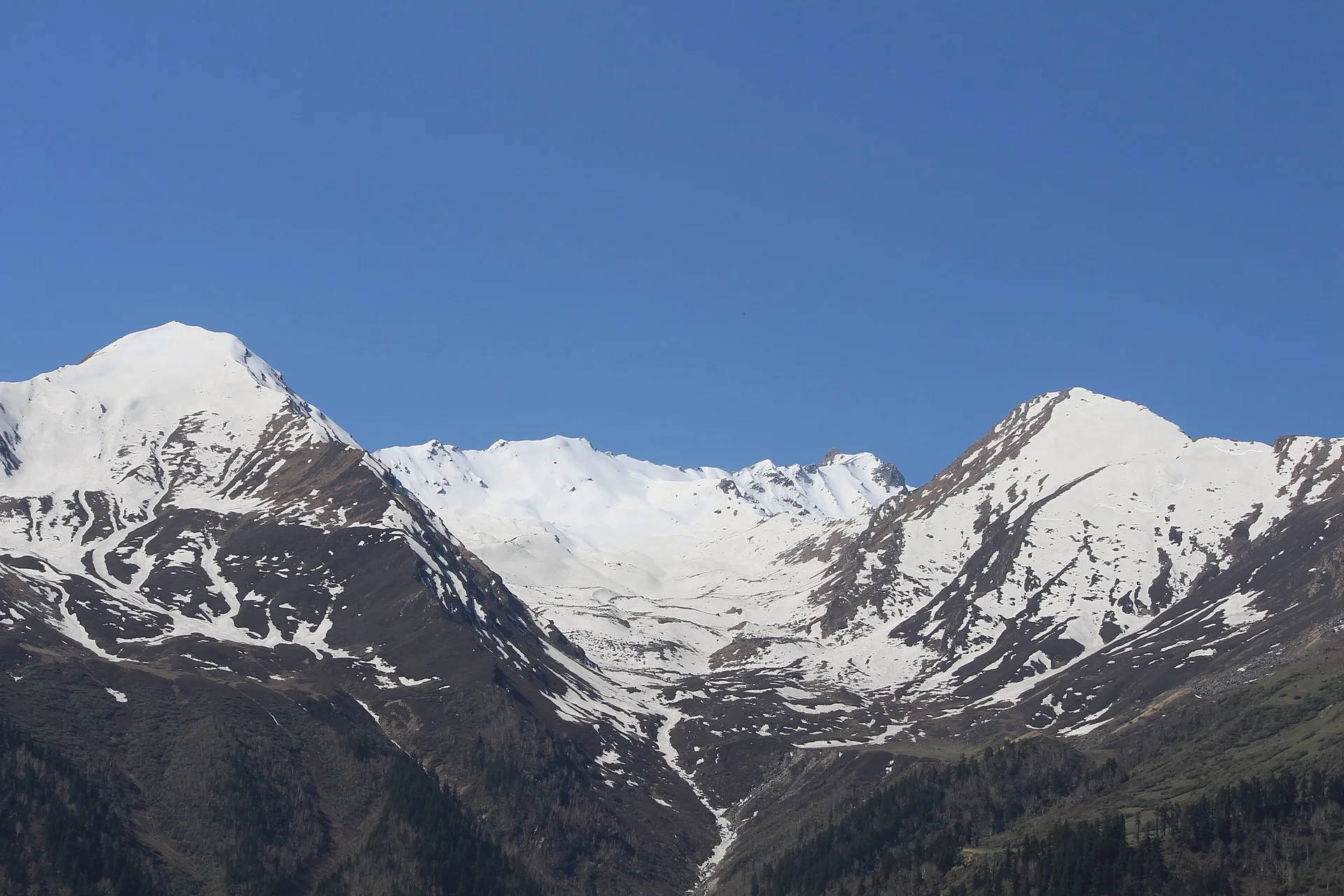
Kalanag Expedition is a name given to the Black Peak Expedition. It is a thrilling adventure for mountaineers to explore the heights of the mountains in the Garhwal Himalayan Range of Uttarakhand, India. Located at about 6,387 meters (20,955 feet) above sea level, Black Peak is the highest peak of the Saraswati Range of Mountains and is also a part of the massive Bandarpoonch Range. The peak has got its local name Kalanag owing to its shape of a hooded cobra.
The trek starts from the village of Sankri and takes an awe-inspiring path through the wild and inaccessible region of Govind Pashu Vihar National Park. The trek goes through the ancient Himalayan villages, thick forests, alpine valleys, and picturesque Ruinsara Tal to reach the Kyarkoti Base Camp. As the trek continues, the landscape changes to rugged glacial valleys, moraines, and snow fields.
This trek entails a strenuous high altitude climbing trek, including glacier crossing, snow slopes, ice and mountain terrain. The approach to its summit is extremely difficult.
With stunning views of the Swargarohini massif, Bandarpoonch range, and the entire Garhwal Himalayas, the Black Peak Expedition is a remarkable adventure in the Greater Himalayan range. It is a major mountaineering goal that represents the natural beauty and grandeur of Uttarakhand's alpine wilderness.
Photos and videos
2 photos · tap to viewHighlights
6 points- Black Peak
- Swargarohini massif
- Bandarpunch range
- Ruinsara Valley
- Ruinsara Tal
- Kyarkoti
Trek Details
- Total Distance
- 98 km
- Best Time
- May–June and September–October
- Base Camp
- Sankri
- Route Type
- Out And Back
- Accommodation
- Tents
- Fitness Level
- Expert
- Family Friendly
- Check with operator
- Season
- Summer, Monsoon, Autumn
- Terrain
- Snow, High altitude, Ridge walk, Rocky Trail, Summit View, Valley
- Departure Cities
- Dehradun, Rishikesh, Haridwar, Uttarkashi, Sankri
- Region
- Garhwal, Uttarakhand, India
Itinerary
15 days · tap a dayDay 1
Dehradun to Sankri
Altitude: Sankri 1,950 m (6,400 ft) Distance: 220 km drive (about 10 hrs)
Day 2
Sankri to Seema via Dhatmeer
Altitude: Dhatmeer 2,400 m (8,000 ft) → Seema 2,600 m (8,500 ft) Distance: 18 km drive (1–1.5 hrs), then a 10 km trek (6–7 hrs) You drive to Dhatmeer and begin the trek along the river through Govind National Park. Seema is a small riverside settlement and the first night in a tent.
Day 3
Seema to Rainbasera
Altitude: 3,100 m (10,200 ft) Distance: 10 km (6–7 hrs) A steady day through forest and alpine meadows, gaining about 500 m.
Day 4
Rainbasera to Ruinsara Tal
Altitude: 3,600 m (11,800 ft) Distance: 7 km (4–5 hrs) A shorter day to Ruinsara Tal, a lake in the Ruinsara Valley, with views of the surrounding peaks.
Day 5
Ruinsara Tal to Kyarkoti (Base Camp)
Altitude: 4,050 m (13,300 ft) Distance: 7 km (5–6 hrs) You move up to Kyarkoti, the Base Camp for the climb. Rest and hydrate this afternoon.
Day 6
Base Camp to Advanced Base Camp (ABC)
Altitude: 4,500 m (14,800 ft) Distance: 5 km (about 5 hrs) The terrain becomes rocky and glacial. You gain 450 m and sleep at ABC.
Day 7
Rest, acclimatisation and load ferry
Altitude: 4,500 m The trek leader decides how to use this day. That might be rest, a short climb to acclimatise, or carrying loads to the next camp. Don’t skip the rest.
Day 8
ABC to Camp 1
Altitude: 5,050 m (16,500 ft) Distance: 2 km (3–4 hrs) A short but steep day, gaining 550 m.
Day 9
Camp 1 to Summit Camp
Altitude: 5,500 m (18,000 ft) Distance: 3 km (4–5 hrs) You move to Summit Camp, your highest sleeping point, and prepare for the summit push. Eat well and sleep early.
Day 10
Summit attempt
Altitude: Summit 6,387 m (20,950 ft), then back to Summit Camp at 5,500 m Distance: 3 km one way (7–8 hrs up), so a very long round trip The final summit climb involves snow and steep slopes. You start in the dark and use crampons, an ice axe, a harness and ropes where needed. The team will turn back if weather or your health requires it.
Day 11
Summit Camp to Base Camp
Altitude: 5,500 m → 4,050 m Distance: 10 km (6–7 hrs) A long descent of about 1,450 m to Kyarkoti, retracing the rout
Day 12
Kyarkoti to Ruinsara Tal
Altitude: 4,050 m → 3,600 m Distance: 7 km (about 4 hrs) An easy walk back down to the lake.
Day 13
Ruinsara Tal to Seema
Altitude: 3,600 m → 2,600 m Distance: 17 km (about 8 hrs) This is the longest walking day of the descent, and it feels it on tired legs.
Day 14
Seema to Dhatmeer, then drive to Sankri
Altitude: Dhatmeer 2,400 m → Sankri 1,950 m Distance: 10 km trek (about 5 hrs), then an 18 km drive (1–1.5 hrs) You finish the trek at Dhatmeer, drive back to Sankri and sleep in a guesthouse.
Day 15
Sankri to Dehradun
Distance: 220 km drive (about 10 hrs, roughly 7 am to 6 pm)
Things to Carry
- 40–50L backpack
- daypack
- trekking shoes
- trekking poles
- gaiters
- backpack rain cover
- headlamp with spare batteries
- Thermal base layers
See all 45 items
- quick-dry T-shirts
- trekking pants
- fleece jacket
- down jacket
- waterproof jacket
- waterproof pants
- warm socks
- woollen cap
- sun hat
- insulated gloves
- spare undergarments
- Water bottles or hydration bladder
- water purification tablets/filter
- energy bars
- dry fruits
- electrolyte sachets
- First-aid kit
- personal medicines
- blister patches
- sunscreen (SPF 50)
- lip balm
- UV-protection sunglasses
- power bank
- charging cable
- camera (optional)
- spare batteries
- Toothbrush
- toothpaste
- biodegradable soap
- hand sanitiser
- wet wipes
- toilet paper
- tissues
- quick-dry towel
- waste bags
- Government-issued photo ID
- Power bank
Compare Operators
Find the best deal
Share your dates and group size, and verified trek companies will send you their prices. Free, no obligation.
Trek Profile
Overall: Extreme
Best Suited For
- Veteran Trekkers
- High Altitude Experience
- Endurance Athletes
Not Ideal For
- Beginners
- Casual Hikers
- People with Health Concerns
Trek reviews
Reviews are opening soon for Black Peak Expedition. Share the route, season, difficulty, and trail experience.
Trail Tales For This Trek
Explore More In Garhwal
Free quotes from operators
Interested In This Trek?